Scunthorpe Steelworks, pictured in 2016, is the last fully integrated steelworks operating in England
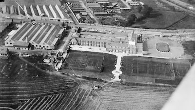
Historic England, a UK government body, has launched the Aerial Photograph Explorer tool, which makes more than 400,000 aerial photographs available to view online for the first time. It includes the first photograph taken by Aerofilms, the UK’s first commercial aerial photography company, on July 26, 1919, two months after the company was founded. It shows its original home at the London Aerodrome, Hendon. All photos: Historic England
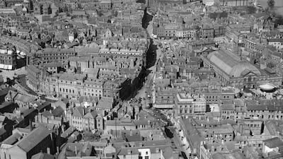
Derby city centre in 1921, looking up at the Corn Market and Iron Gate
Derby city centre 100 years later, in 2021
Here is one of the earliest pictures on the Aerial Photograph Explorer. It shows Ipswich Town Hall and Corn Exchange, and was taken at some time in 1921. The Town Hall, which was built in 1867-68, is the large building with the clock tower and is an example of high Victorian civic architecture
St James’ Park football ground, Newcastle-upon-Tyne, in 1927. Newcastle United entered the 1927/28 season as the First Divisions champions, their fourth and last league title, led by their prolific goal-scoring captain, Hughie Gallacher
The R101 was a rigid airship built by the Air Ministry at the Royal Airship Works, in Cardington, south-east England. Its maiden flight, on October 14, 1929, started with a short circuit over the nearby town of Bedford. Less than a year later, in the early hours of October 5, 1930, the airship crash-landed in France on its maiden overseas flight, killing 48 of the 54 passengers on board
The photography on the Aerial Photograph Explorer reveals the extent to which some English cities have changed. This shot of Birmingham shows the Bull Ring and St Martin’s Church area in 1931
This shows the same area in 2009
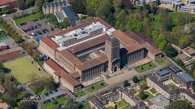
The Cambridge University Library in 1938. The building was constructed between 1931 and 1934 by Giles Gilbert Scott. Though it has been extended over the years, the outward appearance of this distinctive building remains unchanged
The Cambridge University Library in 2013
Crosby, Liverpool, in 1941. During the Second World War, coastal defences took many forms as Britain tried to slow down an amphibious landing from the sea. Here at Blundellsands, near Crosby, large concrete blocks have been positioned to prevent armoured vehicles from moving up the beach
This photograph shows the aftermath of one of the biggest non-nuclear explosions in the world. It occurred at RAF Fauld underground munitions depot in late 1944, killing about 70 people. It is not clear what caused several thousand tonnes of high explosives inside the former gypsum mine to be ignited
Manchester Ringway in 1946. Now called Manchester Airport, it was built in the 1930s and used for active service during the Second World War
Manchester Airport in 2021. Compare it with the 1946 aerial photograph and you can see how much has changed. There are now three civilian terminal buildings and two parallel runways
In this photograph taken in 1946 you can see the extent of the wartime bombing in Liverpool. Near the roofless shell of the Custom House, in the bottom right, and Paradise Street area are large areas that have been cleared of buildings damaged by bombs during the Second World War
Liverpool from above in 2017. Following the clearance of buildings bomb damaged in the Second World War the area was completely re-developed.
Cheltenham, Gloucestershire, in 1947. Sandford Parks lido was opened in 1935 during the golden age of lido construction, when outdoor swimming became popular. Unlike many of the other 1930s lido the Sandford Parks lido is still popular today.
This aerial view of St Paul’s Cathedral, London, taken in 1948, shows the extent of bomb damage to the capital after five years of aerial bombardment during the Second World War. Amid the devastation, St Paul’s survived intact
This post-war view of Coventry taken in 1948 shows the effects of the Blitz and serves as a reminder that bomb damage was a feature of many British towns and cities long after the war had ended. The ruined cathedral is at the centre of the image
Bassingbourn, Cambridgeshire, in 2006. The bold cropmarks mark the site of an important medieval centre originally belonging to the de Bassingbourn family from the 12th century. The origins of the site are thought to be a castle inside a rectangular moat
Bradford Grand Mosque under construction in 2007. It is now one of the largest mosques in the UK and was opened in 2012
The East Yorkshire coastline is rapidly eroding, and several metres of land can be lost during years of extreme weather. This image shows the remains of Fort Godwin in 2009, a coastal gun battery that was active during both World Wars and was built inland. The coastline has receded to the extent that some buildings teeter on the cliff and large parts, including one circular gun emplacement, are on the beach
Hardknott Roman Fort, the rectangular enclosure bottom of frame, is situated in the spectacular setting of the southern Lake District alongside Hardknott Pass, pictured in 2011. It was constructed in the early second century and abandoned about 80 years later
The 2014 flooding of the Great Ouse River over Fen Drayton, Cambridgeshire, looking north-east towards Holywell. The isolated circular mound of a round barrow, a Bronze Age burial site, is visible surrounded by the floodwater in the foreground
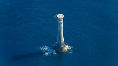
Bishop Rock lighthouse, pictured in 2015, is the most westerly and southerly listed, or protected, building in England. Built by Trinity House between 1852 and 1858, it replaced an iron lighthouse
Scunthorpe Steelworks, pictured in 2016, is the last fully integrated steelworks operating in England